|
Identification of Forest Management Modes by Remote Sensing
Case of the Forest of Fabas ?Haute-Garonne (France)
Jean-Paul LACOMBE, Ecole Nationale Sup?ieure Agronomique de Toulouse
1. Introduction
This project will contribute to a better comparison of the consequences of three types of forestry management (coppice with standards, high forest, coniferous plantation) on the functional diversity of the syrphid communities (aphidiphagous dipterous insects). These insects make it possible to detect significant ecological characteristics for other biodiversity components that are partially dependent on forestry practices. Indeed, the old practices (coppice with standards) influenced forest population diversity. That supported the development of other management ways (forest) more respectful of this biodiversity. There remains to be known if the way a forest is managed is the principal variation factor of population diversity.
The aim of this study is to set up a device of syrphid trapping in the Fabas area forests, to the south-west of Toulouse, on Gascogne hills. These forests are managed in three different ways:
- a private sector, with mostly coniferous trees planted 50 years ago and managed by a forest specialist, a district sector, made up of coppice with oak standards, managed by the French National Forest Office, private and isolated plots managed by farmers (coppice with standards).
- We wish to know if these forestry distinctions are connected with ecological factors affecting species: trees species composition (deciduous tree or coniferous tree), vegetation structure (coppice or high forest), age, vegetation density in various layers, etc.
- More widely, are the species and their diversity influenced by other factors that need a specific study, such as slope, aspect, etc.? A sampling by traps will give us a deeper understanding of the syrphid communities in the study area.
The objective is to provide an informative, easy-to-use cartographic tool, showing the various management units. Thus, it will be easier to locate the sites of great interests where the syrphid diversity can show variations.
2. Hardware and methods
2.1 Sources of information
Topographic map (French National Geographical Institute) of the Fabas area (ref. 1945 Aurignac West, scale 1/25000),
Three panchromatic air Photographs (1993),
Two Spot scenes, XS, level 1B:
February 1998 - the forests are made up of three types of objects: (i) the evergreen vegetation (coniferous), (ii) trunks and branches of the deciduous species and (iii) a winter naked grounds fraction,
July 1998 - the chlorophyllian canopy (deciduous tree and coniferous tree).
Other cartographic documents (Inventaire Forestier National, Institut National de la Recherche Agronomique, Institut de Recherche sur les Grands Mammif?es, Corine Landcover)
2.2 Image processing Software: ENVI
2.3 Image Processing Methodology
- Spot scenes integration to ENVI format,
- Stretching enhancement of images,
- Spot scenes georeferencing and registration (coordinated with "Lambert II ?endu"),
- Spatial subset processing and superimposing of the two scenes,
- Principal component analysis,
- Building and applying thematic mask,
- Non supervised classification,
- Combine classes, color mapping and pixel sieve,
- ArcView input vector files (roads and rivers),
- Cartographic composition
3. Spot scenes Preprocessing
For every scene we use three data bands: XS1 ("green" band), XS2 ("red" band), XS3 ("near infra-red" band). The Spot scenes were integrated to ENVI format then processed with a linear stretching enhancement. The georeferencing and registration process was carried out by selecting ground control points (GCPs) reported from the IGN reference map. For each scene, georeferencing process was performed with 28 GCPs distributed in a homogeneous way. The high-quality RMS shows average variations lower than 1 pixel. The superimposing of the two scenes is very satisfactory. A cross-coloured composition was carried out from the three following data bands:
- XS3 (07.98): highlighting of the chlorophyllian vegetation,
- XS3 (02.98): allowing a right discrimination of winter vegetation (coniferous tree),
- XS1 (02.98): showing areas not covered by winter vegetation.
A Principal Components Analysis (PCA) was carried out from the RGB color combination. The double objective was: (i) decorrelation of the data bands and (ii) maximization of the pixel variability. This process made it possible to increase the image precision and focus.
From this new coloured combination we built a mask removing the pixels not members to forest set. This process was quickly carried out thanks to the regions of interest tool in ENVI (ROIs). Then the file masked band was applied to the RGB color combination.
4. Classification
We carried out a non supervised classification (by the K-Means method). We fixed the following parameters:
- Initial Number of classes: 15,
- Initial Number of iterations: 10,
- Change threshold: 5%.
The classification process reached a steady level with six iterations. Twelve classes linked to the theme forest were preserved. The other classes were empty or did not belong to the topic forest. A combine class made it possible to contract map key. Lastly, isolated pixels were removed but the classes were not smoothed out, so as to keep more details. (Click on images below for larger views.)
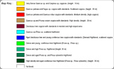
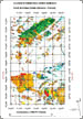 Green color mapping indicates coniferous trees. Blue color mapping indicates simultaneous leafy and coniferous trees. Hot colors mapping (yellow, orange, red, brown) indicate deciduous trees. The colour gradation, used in every previous categories, makes it possible to distinguish these classes according to the age of the trees and the vegetation density. The darker the tone the denser and older the tree population. The adequacy between ground data and classification is excellent since the quality of classification is close to 90%.
5. Comparison with other scientific results
All in all, map key is the same as that of other research. However our classification allows to extract more classes with accuracy. On the other hand, some forest items were not specifically attributed:
The INRA classification map shows many larches in the coniferous area. It shows two separated classes ("thick spruce planting" and "thick woodland pine planting") whereas we found only one: "thick spruce and woodland pine forest".
The IFN classification map shows the afforestation type. This map, in agreement with information extracted from air photography, shows that the density differences in the coniferous tree area correspond rather to different plantation types (full sowings and stripes sowing). On the other hand it is much less sharp because it shows fewer classes. The IFN data show us that the district forests are primarily made up of deciduous trees whereas the private forests are almost exclusively made up of coniferous tree plantations.
6. Conclusion
From a thematic point of view, this work made it possible to lead an accurate forest classification that permits to give information on management. This information is essential to define syrphid trapping sites. These data will make it possible to better know the distribution of the settlements of these bioindicator insects through three broad criteria: tree species, forest structure and density. Analysis of Syrphid distribution patterns will permit to compare the biodiversity within three levels: (i) final stages of the three forest management, (ii) the same ages and (iii) various ages within the same management way. Thus, this work will bring forest managers (Office National des For?s, expert foresters) information for a better consideration of the functional and patrimonial value of biodiversity.
Materially, software ENVI enabled us to work accurately and easily, it is user-friendly enough to permit intensive use. The user is not overwhelmed by this powerful and high-performance tool, quite the contrary. Its numerous functions permit thorough studies. ENVI makes it possible to tackle complex problems and projects on a large scale. Its interactivity with other software products and its compatibility with many input/output formats enable to solve problems quickly.
|