- AIR, Corp Uses ENVI to Determine Accuracy of Insurance Claims
- ENVI Helps Facilitate Peanut Crop Health in Australia
- HANTS - Harmonic Analyses of NDVI Time-Series
- Precision Farming with ENVI
|
|
|
 |
|
- Customer Challenge
Every year, thousands of insurance claims are filed with individuals seeking compensation for natural disasters, such as flooding and hail, which have damaged or destroyed their agricultural fields. Though some of these claims are genuine and reflect farmers' financial vulnerability,a number of the claims are fraudulent. Air, CORP of Columbia, MO needed a way to help their government clients determine which claims were fraudulent.
- Solution Achieved
AIR,Corp founders John Brown and Maria Brown used satellite imagery and ENVI to develop a system for determining the legitimacy and extent of natural disaster damage on farms. Since 2000, they've solved over twenty agriculture insurance fraud cases for the U.S. Department of Justice, USDA Risk Management Agency and private insurance companies.
In a typical case, John Brown analyzes historical Landsat imagery to determine if the crops in question were actually planted, the types of crops which were planted, and to estimate yields on specific fields. Air,Corp has trained over 22 federal employees to use vegetation-specific and tools and algorithms in ENVI to verify claims and identify potential fraud. Their work in the past five years has proven that a significant percentage of fields for which damage-related insurance claims were filed were never actually planted.
AIR,Corp estimates that the cases they have solved exceed $30 million dollars in unpaid claims. In areas where they have proven fraud, and where federal trials have been held to prosecute the offenders, surveys show that agriculture-related insurance fraud has been reduced significantly.
Because of the innovative approach developed by Air,Corp and Maria Brown, ENVI is now the primary analysis tool used by the Risk Management Agency for crop evaluation and fraud detection. In addition, AIR,Corp is now using ENVI to resolve water-related issues in agriculture and urban water supplies. Says Brown, "We have successfully used imagery from 1974 to the present to demonstrate water use in irrigated fields in Texas around major aquifers. We are also in the process of employing satellite water analysis to detect illegal water use."
- Benefits
- Using ENVI, Air, Corp created a solution wherein insurance companies can now discover and prove fraudulent insurance cases
- Using ENVI and Air, Corp's solution, the U.S. Federal Government saves millions of dollars by not paying fraudulent claims
- AIR,Corp can now help assess claim damage by comparing new imagery to historical imagery.
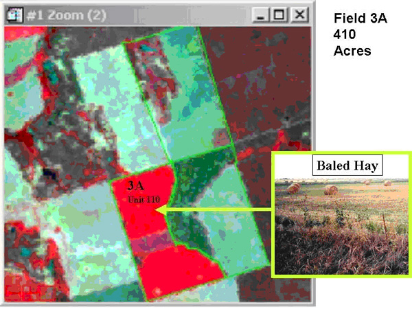
Air,Corp uses remote sensing and ENVI to detect casesof fraudulent insurance claims on farms.
Image credit AIR,Corp.
|
|
|
 |
|
- Customer Challenge
Growing peanuts is a delicate and precise process. Peanut plants do not flower and dry off as they mature, like wheat or corn, but continue to flower indeterminately and grow their pods underground. This makes it extremely difficult to surmise when they are ready to be harvested, which has resulted in a $6.3 million annual loss to the Australian economy. In addition, many crops can be lost to contamination by aflatoxin. To combat these issues, farmers and researchers needed a way to determine optimal harvest times, and to detect aflatoxin in dry-land peanut crops.
- Solution Achieved
Ph.D. Scholar Andrew Robson analyzes QuickBird Imagery using ENVI to determine peanut maturity and the presence of aflatoxin, a mold that contaminates seedlings of peanut plants. Using a combination of techniques, Robson is able to identify areas of stress in peanut crops, preventing further aflatoxin contamination by allowing farmers to focus their treatment efforts. Robson's techniques also provide the capability to produce harvest maps, which are used by farmers to maximize crop yields.
In his satellite image analysis processing, Robson uses ENVI to perform point registration, using both image-to-image and image-to-map capabilities to pinpoint target regions of interest (ROIs) within crops and index those ROIs using NDVI and SAVI. After subsetting the ROIs, Robson performs classified and unclassified analysis as well as density slicing to identify areas within each ROI for peanut maturity and aflatoxin existence. The results of the analysis of the satellite imagery proves high correlations between classified NDVI image color zones with peanut maturity, yield and stressed areas prone to aflatoxin contamination.
ENVI allows Robson to perform change detection between sequential images and highlight areas of significant change. Analysis of seasonal images and change detection results allow farmers to assess which areas reflect disease-related canopy loss and focus treatments on those areas to prevent further spread. Final images in effect become a harvest map, enabling the grower to form a harvest management regime that maximizes yield and quality, while minimizing prolonged disease exposure.
Robson employs field spectroscopy and Near Infrared Light (NIR) spectroscopy to identify the level of kernel maturity in target areas, thus allowing him to determine optimal harvest time. Since spectral signatures differ according to kernel maturity levels, he can classify and map wavelengths in canopies, kernels and shells in three maturity grades - immature, mid-mature and mature. Robson has been able to identify specific wavelengths from the peanut canopies that correlate with peanut maturity using ENVI. With ENVI's spectral library builder, he converts .txt files to spectral library files to view data, perform data smoothing and identify spectral ROIs.
Looking to the Future
Robson's application has been well received by peanut growers throughout the South Burnett, Queensland area, and has been tested in five other cropping regions in Australia. The success of using satellite and spectroscopy imagery and analyzing it with ENVI has led to plans to commercialize the solution for future crop years. His resourceful discovery of the correspondence of unique wavelengths to peanut maturity will result in constructing LED sensors to be mounted on irrigation booms or tractors, allowing farmers to produce low-cost maps throughout the growing season. Similarly, the application of spectral signatures and their connection to aflatoxin could lead to developing in-line sensors for quality assurance in Australian peanut mills.
- Key Benefits
- Using ENVI, farmers and agriculturists can now harvest peanuts at a more optimal time.
- Since harvesting crops too late can cause losses in the millions of dollars, this solution saves farmers a significant amount of money on lost crops.
- ENVI's built-in functionality allowed researchers to do the analysis they needed without the need for third party products. It is an all-inclusive solution.
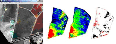
Left is a RGB image from a multispectral QuickBird satellite. Right are QuickBird satellite images of a peanut crop taken three months apart showing change detection.
Images courtesy Queensland Department of Primary Industries
|
|
|
 |
|
- Customer Challenge
Researchers at the Cdentre for Geoinformation in the Netherlands needed to process NDVI time-series from the SPOT-VGT sensor, using ENVI, over a period of five years to investigate phenology differences between landcover types, and how weather conditions affected the differences.
- Solution Achieved
Researchers used IDL and ENVI together to implement the HANTS algorithm in conducting their research. The Hants algorithm filters the time-series based on fourier transforms. The team used IDL, as it an easy solution for implementing the iterative, FFT (Fast Fourier Transform)-based filter. Using the filter allowed them to filter the clouded points in the NDVI time-series. After filters were applied, ENVI was used to implement intuitive visualization options, such as image tiling. Researchers at the Centre chose ENVI for its flexibility and capability of handling diverse data types, "particularly including complex values and plot Z-profiles were very practical," said Allard de Wit of the Centre, "The result of the HANTS algorithm is a efficient way of cleaning up the NDVI-timeseries which could be used successfully to derive the start-of-growing season for different land cover types and years in the Netherlands."
- Key Benefits
- Using ENVI and IDL, De Wit "cleaned up" the NDVI-timeseries images, which could then be used successfully to derive the start-of-growing season each year in the Netherlands based on land cover types.
- The ability to customize ENVI using IDL allowed him to integrate the algorithms necessary to perform the complex processes.
- De Wit used ENVI's ability to process diverse data types in order to complete his research.
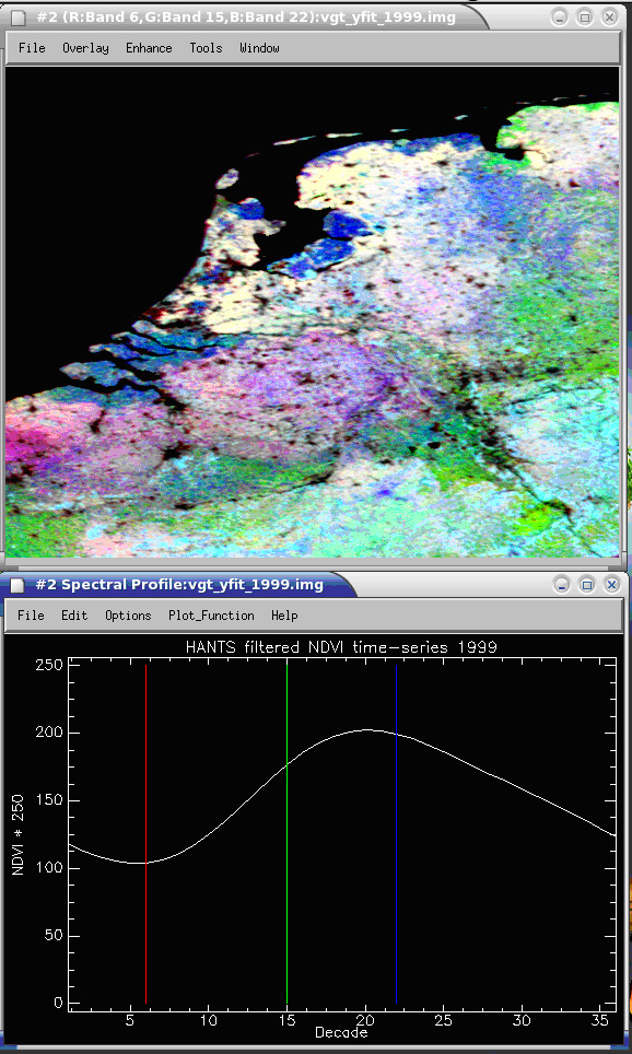
Top: RGB composite of NDVI images from the Netherlands show improvements after filtering with the HANTS algorithm. Bottom: Time-seriesNDVI values demonstrate smoothing results after filtering with HANTS algorithm
Images courtesy Allard de Wit, Centre for Geoinformation, Wageningen-UR, The Netherlands
|
|
|
 |
|
- Customer Challenge
Vintners in California needed an imaging solution to improve irrigation and nutrition management, make crop adjustments, and monitor disease and pest populations.
- Solution Achieved
Susan Mahler and Paul Skinner of Terra Spase, located in Napa, California are using airborne remote sensing data, in combination with soil sample analyses, to help vintners improve irrigation and nutrition management, make crop adjustments, and monitor disease and pest populations. At harvest time, the imagery enables vintners to plan harvesting strategies for reaping fruit at a similar and proper level of maturity.
"We tried everything when we were looking for a software solution. What we really like about ENVI is that it is a complete package," Mahler says. "It also has a good interface, handles our archived, ".tiff" data and is competitively priced."
Using ENVI, Terra Spase analyzes four-band data (in the blue, green, red and infrared spectrums, collected from 15,000 feet, with two-meter resolution*) gathered during the growing period and near harvest-time. The pre-harvest data is processed to evaluate the canopy density of each part of a vineyard and is represented in a blue-green-red-yellow scheme. Areas of the vineyard that show up blue have a weak canopy or none at all; sections that are represented in yellow have a very dense or vigorous canopy.
Experienced vintners know that grapes, which are very sensitive to their environment, are influenced by sunlight levels. By using ENVI to process and visualize the data, you can determine where the canopy is too thin or too thick and grapes are being under- or overexposed to the sun. Vintners also can see where they may need to alter irrigation levels, modify fertilizer applications or prune vines to optimize their production and quality.
Vintners using this precision-farming technique also may be able to detect anomalies in the canopy caused by crop-threatening insect infestations, for example spider mites and leaf hoppers, or the presence of a spreading fungal disease, such as Botrytis.
"The vineyard owners that use the imagery we produce are able to see so much more than they used to," says Skinner, founder of Terra Spase. "People are very excited about its possibilities." Skinner's experience with vineyards includes many years of traditional analysis methods, including personally visiting vineyards to assess their growing potential first hand. In concert with soil sample analyses, for characteristics such as pH, nutrient content and texture, Skinner's use of ENVI imaging creates a unique opportunity for his clients to learn more about their vineyard, and optimize their crop production and quality.
Exelis Visual Information Solutions' Global Services
Terra Spase wanted an automatic system to access data files archived from past remote sensing flights. They needed their solution quickly and couldn't afford the time and money it would take to create this batch process. As a solution, they decided to use Exelis Visual Information Solutions' Global Services group, a team of application development engineers who specialize in software development.
"The Global Services group was exceptionally responsive, even though we aren't a Fortune 500 company," says Mahler. "They quickly turned the project around at a very reasonable cost."
Terra Spase's requirements were determined with the help of the Global Services group's development engineers. According to Amanda Malone, Manager of the Global Services group, "Using IDL and ENVI routines, we created a custom application to read in hundreds of data files and process them automatically."The Global Services group-developed batch routine process includes NDVI (Normalized Difference Vegetation Index) and isodata classification as .tiff output. "The resulting isodata classification images allow us to isolate individual vineyards for study," Mahler says.
"The Global Services group went beyond the initial specifications," Mahler adds. "They included a custom GUI that makes it simple to modify color tables, define thresholds and other isodata parameters."
- Benefits
- With the help of ENVI and the Global Services group, Terra Spase has been able to improve its services and expand its business.
- By combining their depth of experience with new remote sensing technology and precision farming methods, Terra Spase is enabling some Napa Valley vintners to farm their land more efficiently, increase profits, head off disease and deliver a better product.
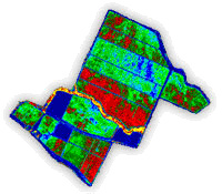
Vineyards in Napa Valley are producing better wine and refining their growth and harvesting processes with the help of data processing and imagery produced with ENVI.
Image Credit Terra Space
|
|