- Digital Terrain Model with Landsat Images
- French Space Agency Uses ENVI to Study Ecosystem Evolution
- Indiana University Uses IDL & ENVI to Enhance Geology Instruction
- Using ENVI and IDL to Study Geological Processes on the Surface of Mars
|
|
|
 |
|
- Customer Challenge
Decision makers in Flores, Indonesia required visually intuitive representations of surface features in Komodo National Park. A research project prompted Muhammed Barnawi to find a way to providebetter interpretable visualizations.
- Solution Achieved
Barnawi used ENVI to create Digital Elevation Models (DEMs), which provide him with 3-D, accurate representations of surface features in regions of interest. In addition to DEMs, ENVI's bult-in annotation tool helped him to create intuitive color composites to focus on areas with no cloud cover. ENVI's hill shading analysis tool also allowed him to combine the color Landsat composite image with the digital elevation model, creating a representaion of surface features in the park.
- Benefits
- Using ENVI and Landsat images, Barnawi better able to represent surface features in the Komodo National Park.
- ENVI's built-in capabilities allowed them to easily present their data.
- Creating color composites in ENVI is easy - especially when compared with other methods.
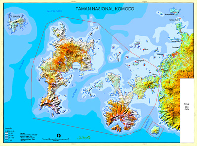
A Digital Elevation Model (DEM) created in ENVI of Komodo National Park
Image courtesy Gadjah Mada University, Indonesia
|
|
|
 |
|
- Customer Challenge
The French Space Agency, CNES (Centre National des Etudes Spatiales), launched their VEGETATION project ten years ago. They needed a way to process and analyze data on a daily basis to represent the time-sequenced evolution of ecosystems, natural and cultivated vegetation, and even water and icebergs on earth.
- Solution Achieved
The answrer to that need was CNES' VEGETATION project, which succeeded in implementing a system of data acquisition from satellites for the entire globe. The daily work of the international teams on the VEGETATION project is to register images at regular intervals in order to transmit them as quickly as possible to the end users. The data images are saved and transmitted in raw form to their clients. Most of these clients also use ENVI to analyze remote sensing images.
Many users of the VEGETATION project data using ENVI enjoy the software's capability to manipulate large amounts of data. This is important because a simple set of data from the entire globe represents about two GB and users are working with several sets of data simultaneously, up to 36 in a single year.
"The entire VEGETATION project team appreciates the proactive nature of Exelis's technical support department," said a CNES spokesperson, "The only difficulties encountered were small technical problems due to our poor understanding of the software at the beginning, and the uniqueness of our requirements. In the former case, we immediately received the appropriate assistance, and in the latter case,ENVI developers integrated our requests in the next version release of the software. This allowed us to really automate our data processing. I can honestly say that the entire technical support team has always been very responsive to our needs!"
- Benefits
With satellite data and ENVI, they can now process and analyze daily data to represent time-sequenced evolutions of ecosystems, vegetation and water and icebergs on Earth CNES chose ENVI as their image processing software because it is the only commercial software that allows them to read HDF data, and ENVI allows them to manipulate large amounts of data, since they are working with massive datasets from the entire globe ENVI's functionality and extensibility using IDL allows for complex iterative analysis, in particular time sequenced data analysis. IDL is a powerful application development environment that allows detailed data analysis with high-end visualization and analysis functionality.
ENVI helpsThe French Space Agency's VEGETATION project clients to better understand the evolution of natural or cultivated vegetation, as well as forecast harvests and study changes in land use.
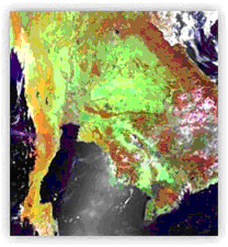
Image ⓒ Credit CNES
|
|
|
 |
|
- Customer Challenge
The Indiana University Department of Geology needed to calibrate instruments and spacecraft, as well as analyze hyperspectral satellite data and extract diagnostic spectral features for the identification and discrimination of minerals and rocks, soil types, vegetation species and the assessment of conditions of these materials.
- Solution Achieved
For instruction of undergraduate students, the department uses ENVI and IDL. The students register for three courses, wherein they use ENVI + IDL to complete their laboratory assignments: Geological Remote Sensing, Planetary Remote Sensing, and Planetary Geology. The department of Geology, IUPUI, uses ENVI to calibrate spacecraft, satellite and airborne hyperspectral data such as OMEGA, Hyperion and AVIRIS imagery, and to extract diagnostic spectral features.
ENVI's ease of use and flexibility were the primary reasons the department chose it as a primary teaching tool. According to Lin Li, Assistant Professor in Geological and Environmental Sciences for the Department of Geology at IU, "The ENVI user interface is very friendly. A novice can easily learn through hands-on exercises."
For students just learning to use remotely-sensed data, Lin was impressed with ENVI's ability to read remotely sensed data in a variety of formats. "The spectral feature analysis and subpixel analysis tools are very powerful, and they have been used in various applications," said Lin, "ENVI is also capable of handling field spectra with built-in functions, such as resampling, data format conversion and MNF transformation."
In addition to powerful fucntionality and ease-of-use, the department appreciates the comprehensive reference manuals, which clearly outline each ENVI function.
- Key Benefits
- Students can now easily learn to process hyperspectral, remotely-sensed data as part of their curriculum.
- The spectral feature analysis and subpixel analysis tools are very powerful, and they have been used in various applications," said Lin, "ENVI is also capable of handling field spectra with built-in functions, such as resampling, data format conversion and MNF transformation."
- ENVI's ease of use and flexibility were the primary reasons the department chose it as a primary teaching tool.
|
|
|
 |
|
- Customer Challenge
In order to study the geomorphology of mars, planetary geologists from Paris' Institute of Physique of the Earth needed a flexible image exploitation solution that provided built-in analysis capabilities, while allowing customization to meet the needs of scientists in the various disciplines that make up the team.
- Solution Achieved
Geomorphology - the study of landforms, their origin, and evolution - is used by researchers to help scientists determine how weather, time and other factors affect planets. Understanding how other planets have fared over time can help us to understand what the future holds for our planet. At the Institute of Physique of the Earth in Paris, a team of geologists studied the geomorphology of the Martian surface to determine how the planet's surface compares to that of the Earth, and to understand their similarities and differences.
In order to study the geomorphology, the team requires large amounts of image data from the planet, which is 46,000,000 miles from the surface of the Earth. To obtain data, they used state-of-the-art, high definition remote sensing instruments, and ENVI and IDL for processing and analysis their data. The sensors were The Mars Odyssey's Laser Mars Orbiter Laser Altimeter (MOLA) instrument, and the Mars Express' High Resolution Stereo Camera (HRSC) instrument.
The team chose ENVI for its industry-leading, built-in image analysis and visualization capabilities that could be easily customized to suit their specific requirements. The end result is a unique solution that allows scientists to quite easily perform complex analyses on the data and subsequently determine the planet's geologic makeup, map land areas, and create large-scale visualizations.
Throughout the innovative project, the geologists used ENVI for most of their image processing needs, including:
- Extracting raw data and presenting models of Martian surface features
- Creating image mosaics - compilations of multiple images
- Creating classified maps categorizing different types of land cover
- Creating DEMs (Digital Elevation Models), which provide spatially accurate, 3-D representations
- Solution Achieved
- Researchers are able to use remotely sensed data and create accurate representations and analyses to understand the topography of Mars, in turn understanding more about the Earth.
- ENVI is easily customized using IDL - the team has built in functionality available and flexibility to create custom functionality in the same package.
- Scientists from many different disciplines working on the project can collaborate and use the same tools - IDL and ENVI - for their analyses
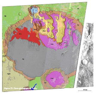
Researchers used ENVI and IDL to create a geological map of the Terby crater on Mar from THEMIS MOLA and MOC datasets.
Image courtesy Institute of Physique of the Earth, Paris
Numerical simulations created with IDL make it possible to extrapolate experimental results of granular mass breakdown.
Image courtesy Institute of Physique of the Earth, Paris
| |
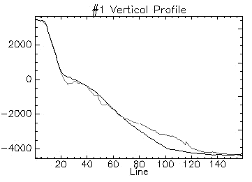
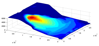
Plot shows a numerical test of an avalanche of rock, starting from altimetric data acquired from the Mars Odyssey's MOLA remote sensing instrument.
Image courtesy Institute of Physique of the Earth, Paris
|
|
|