|
Synoptics Geo Applications Maps the World's Frontiers with SAR Data Using IDL and ENVI
Completely automated process allows for commercial production of Digital Elevation Models and Ortho-rectified images
Because Synthetic Aperture Radar can penetrate cloud cover, darkness, vegetation and other obstacles, SAR data is often the preferred type of data for areas typically subject to those barriers. However, the availability of SAR-related routines has been limited. Synoptics Geo Applications Limited has capitalized on that need by using IDL to create a product line of DEMs, Orthorectified images, and maps that take full advantage of SAR's benefits and can be cost-effectively provided for virtually any location in the world.
SAR Sensors - Past, Present, and Future
ERS-1: Launched by the European Space Agency on July 17, 1991 and retired on March 10, 2000.
RADARSAT: Launched by the Canadian Space Agency in November1995.
ERS-2: Launched by the European Space Agency on April 21, 1995.
Envisat-1: Launch scheduled for June 2001, by the European Space Agency
RADARSAT-2: Launch scheduled for 2003 by the Canadian Space Agency (CSA) and MacDonald Dettwiler.
|
Why SAR?
Like normal photography, SAR data can be used to derive a three-dimensional view of a surface by combining two images taken of the same location from different viewing angles. The ability of SAR to penetrate visual obstacles, coupled with the growing number of SAR instruments available, make SAR data an increasingly poplar choice for remote sensing exploration.
"I am continually amazed by the geometric accuracy available through SAR instruments, especially considering that this can be achieved without ground control," said Dr. Andy Sowter, managing director at SGA. "The geometric capability of SAR is very high; the researcher does not have to struggle with tiepoints and warping scenarios to try and fit their segmentations and classifications to a map grid, for example."
Despite the benefits and growing abundance of SAR data, Dr. Sowter found the availability of powerful, SAR-related routines to be scarce. "Although SAR has been around for more than 10 years, I - and most of my former colleagues who have come out of research - still find that the software offered by most remote sensing and GIS providers falls short in content and understanding." Dr. Sowter and his colleagues therefore decided to fulfill that need, and have developed a set of IDL-based routines that successfully implement SAR data in a commercial environment.
The team at SGA had several goals in mind when they developed the SAR routines. One, they wanted a system that could operationally generate DEMs and ortho-rectified images from large datasets. Secondly, they wanted a system that required as little human intervention as possible. Thirdly, they needed to process images without the use of special hardware. Lastly, they wanted the ability to update algorithms as rapidly as possible.
IDL Provides Powerful, Easy to Learn Development Environment
When it came time to select a development environment, IDL was Dr. Sowter's first and only choice. "I, and many of my colleagues, have been using IDL for years in our research. Throughout those years, IDL has become an invaluable tool for implementing and prototyping mathematical ideas and constructs, and viewing the results easily. IDL is also easy to program and allows you to fix bugs on the fly. In addition, IDL gives you the ability to interrupt and inspect intermediate image products and monitor your progress through graphical windows and log file output," Dr. Sowter said.
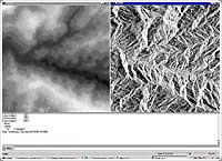
This is a snapshot of the IDL processing environment for the generation of DEMs. The environment displays a window showing the stereo disparity on the left, which is updated throughout the process, and the master image on the right for reference. The IDL log window outputs monitoring information and the values of certain convergence parameters to show progress. This particular example shows an area in the Leuser National Park, Sumatra.
In developing the routines, Dr. Sowter and his colleagues wanted focus on routines that created easy-to-use products to meet the needs of a varied customer base. "Our customers have a wide range of expertise in both programming and in remote sensing, so we wanted to create very automated solutions. The IDL interface runs through a single command entry, and monitors progress. That way, the user has to do little more than put the data in a CD drive. We also wrote the routines to allow integration with a GIS, since many of our customers want that option," he said.
The techniques are implemented on Pentium 450 PCs running Windows NT and 98 with 256MB of RAM. Data is input via a CD-ROM, stored on a local 10 GB hard drive, and can be delivered on a CD-ROM.
"IDL is the best tool available for manipulating and managing algorithms to process images and image-like arrays," he continued. "The most useful functionality I have found in IDL is that image display is very accessible to a novice programmer like myself, and TV and TVSCL are constantly in use. When processing, I can set up a display configuration that allows me to monitor these images as well as check the IDL log in real time, so I always know exactly where I am and what my results look like. This saves me a lot of time and allows me to break in and tweak any critical parameters whenever I want. Debugging is allowed in any run, which enables me to fix a problem on the spot, rather than to have to run the whole program again, which can usually take several hours," he added.
Dr. Sowter also uses the IDL/PVWave newsgroup often, and has found useful help and suggestions from other scientists trying to solve their problems. "I don't know of any other tool supported so well in this context," he said.
ENVI Provides Viewing and Editing Environment
Dr. Sowter also selected ENVI as the product inspection and editing environment. "ENVI interfaces easily with IDL, can be customized, and allows export to other formats," he said. "ENVI is very useful for viewing the results in a geographic coordinate system, where other layers can be added to check consistency. Also, the mosaicking tool is very easy to use when trying to merge many large datasets at once."
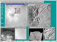
This is a screenshot of the DEM editing process. Here, ENVI is used to eliminate anomalies in the DEM (left) due to layover, shadow and poor convergence. This process is aided by the visualisation of the ortho-rectified image (right) and an Anaglyph (not shown). The area shown is of the Gunung Gureudong volcano in North Sumatra.
"I consider myself a scientist, not a programmer. As such, I appreciate that IDL and ENVI allow me to get straight to the technical problem without having to deal with the programming issues to any great extent. By reading the manuals and watching the Newsgroup, I realize that I probably don't understand or use some of the more sophisticated methodologies and routines used by the professionals. However, I'm somewhat relieved that I don't need to understand them to create good, working code," Dr. Sowter concluded.
About Synoptics Geo Applications Limited
Synoptics Geo Applications Limited (SGA) is a UK-based company devoted to Earth Observation. Formed in 1999, SGA is quickly establishing itself as a world leader in the application of Synthetic Aperture Radar (SAR) to mapping and monitoring. SGA provides cost-effective and rapid mapping solutions, consultant services and training programs in all aspects of SAR, concentrating primarily on Land applications.
SGA is well known for the ability to provide 3-D mapping solutions for areas in which no maps exist. Such areas, located mainly in the equatorial region, are experiencing accelerated economic growth and accurate maps can help in their expansion.
SGA supports several markets, including Oil and Gas Exploration, Telecommunications, Environment Modeling, Agriculture and Forestry. SGA's stereo products, such as Digital Elevation Models, Orthorectified images, Base Maps and Anaglyphs are derived using an in-house process that requires no ground control whatsoever, guarantees an accuracy of 30m RMSE in XYZ, and can be derived quickly and cost-effectively over anywhere in the world.
For more information, visit http://www.synopticsga.freeserve.co.uk (☞)
|